Burton and Swadlincote's glorious April heatwave is on the wane - with rain and cooler temperatures forecast for the coming week.
Temperatures reached more than 20C last week and into the weekend, but now a colder spell is heading to the UK over the next few days.
Temperatures in Burton and Swadlincote are set to drop to 12C by Thursday, April 26, with showers of rain expected throughout the week.
Wednesday, April 25, is predicted to be the hottest day of the week although temperatures will only reach 13C.
But East Staffordshire and South Derbyshire look like getting off lightly compared to other parts of the country, with a threat of frost, sleet and even snow in parts of Scotland, Wales and northern England.

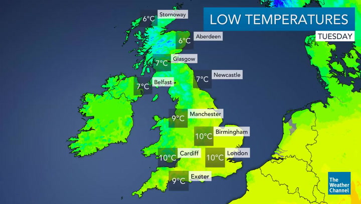
It could even plummet to as low as -2 or -3C over high grounds in Scotland and may linger only a few degrees above freezing elsewhere.
The chilly outlook will be a complete contrast from last week's early taste of summer when temperatures soared up to 10C above the seasonal average under clear blue skies.
According to computer models, an area of wet and windy low pressure will become positioned close to Britain during the last week of April, forcing the mercury to come crashing down after rocketing well above 20C.
From Monday, conditions will become much cooler, cloudier and unsettled as westerly winds from the Atlantic sweep across the country and banish the recent tropical blast of Mediterranean air.
Dr Michael de Villiers, senior meteorologist at The Weather Channel, said forecast models indicate that there will be a chillier spell this week and at the end of the month.
He said the current outlook shows "a tongue of colder air migrating southward in the wake of low pressure and ahead of high pressure building from the Atlantic."
He said: "In the UK minimum temperatures are expected to lower to around 4-6C with a low risk of frost. However, they will be closer to freezing at around 3C in places in Scotland with the risk of brief early morning frost, and lower to around 0C at higher altitude where any precipitation would be in the form of sleet, or wet snow briefly, during the colder early morning hours.
"In fact, temperatures high up in the Highlands will already be near to freezing during the early hours of the morning from Wednesday for brief sleet, or light wet snow."
All parts of the UK are expected to experience rain this week as the weather reverts to more typical conditions for the time of year.
Scattered April showers and brief bursts of sunshine will be a prevalent feature across the country during the first half of the week.
But it will become much more unsettled and cooler by midweek, with the risk of wintry showers in the north and the possibility of thunderstorms to return further south.
The changeable, cooler and gloomy conditions are also forecast to continue into the weekend.
Leon Brown, chief forecaster at The Weather Channel, said: "It will be quite a lot colder from the middle of the week for the west and northwest.
"I expect we will see hail and some heavy April showers next Wednesday and Thursday across much of the UK. Cracks of thunder are possible too."